


Descrizione di US Topo Maps Free
Easy to use outdoor navigation app with free access to the best topographic maps and aerial images for the USA.
*** Please use USGS National Map or OSM if you need most recent maps ***
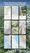
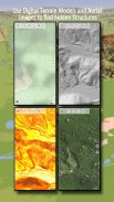
Choose between >20 map layers (topos, aerials, sea charts, flight charts, ...)
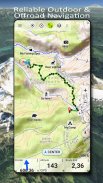
Turn your Andoid Phone/Tablet into an outdoor GPS for trips into the backcountry.
This app gives you similar mapping options as you might know from Garmin GPS handhelds.
Main features for outdoor-navigation:
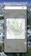
• Download of map tiles for OFFLINE USAGE (PRO-VERSION ONLY !)
• Display Real-Time nowCoast Weather Information and NEXRAD Weather Radar
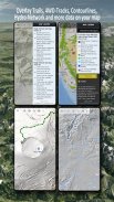
• Free access to more than 100.000 seamlessly stitched USGS topographic maps - easy to use as browsable map layer
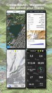
• Create and edit Waypoints
• GoTo-Waypoint-Navigation
• Create and edit Routes (PRO only !)
• Route-Navigation (Point-to-Point Navigation)
• Track Recording (with speed, elevation and accuracy profile)
• Tripmaster with fields for odometer, average speed, bearing, elevation, etc.
• GPX/KML/KMZ Import/Export
• Search (placenames, POIs, streets)
• Customizable datafields in Map View and Tripmaster (e.g. Speed, Distance, Compass, ...)
• Share Waypoints, Tracks or Routes (via eMail, Dropbox, Facebook, ..)
• Use coordinates in WGS84, UTM or MGRS/USNG (Military Grid/ US National Grid)
• Get NWS Weather Forecast
• Track Replay
• and many more ...
Available map layers:
• USGS DRGs: Seamless coverage of topo maps of the USA at Scales 1:250.000, 1:100.000, 1:63.000 and 1:24.000/25.000
• USGS High Resolution aerial imagery
• USGS National Map
• Orthoimagery for conterminous US
• Google Maps (Satellite images, Road- and Terrain-Map)
• Bing Maps (Satellite images, Road-Map)
• Open Street Maps
• Earth At Night
• FSTopo Forest Maps
• NOAA Nautical RNC Charts
• Public Land Ownership (Padus)
• Flight Charts
Available map overlays:
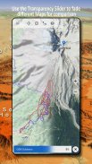
• Hillshading overlay layer for OSM, Google or Bing maps (PRO-VERSION ONLY !)
• Ridge Weather Radar NWS
• Wind, Temperature, Pressure
• Wind Vectors
• Precipitation Estimate - 1-hr
• Precipitation Forecast 24h
• Surface Air Temperature
• Hazard Warnings
• Tropical Cyclone Track
• Wind Vector Forecast 24h
• Max. Air Forecast 24h
• Min. Air Forecast 24h
USGS DRG topographic maps:
The 7.5-minute maps (1:24.000/1:25.000) are the best maps for outdoor activities in the USA. Although some of the maps are quite old, they contain many small pathes and 4WD tracks that are missing in new USTopos, Google, Bing and OSM maps.
New US Topo Maps:
US Topo maps are a graphic synthesis of The National Map data files and are produced in the familiar 7.5-minute by 7.5- minute geographic format. Current US Topo map layers include an orthoimage base, transportation, geographic names, topographic contours, boundaries, hydrography and woodlands. Also included are the Public Land Survey System (PLSS) and the United States National Grid.
NAIP Orthoimagery:
Seamless coverage of contiguous US with 1m/pixel resolution
HRO aerial imagery:
High resolution arial photos covering US urban areas & borders (up to 10cm/pixel)
Use this navigation app for outdoor activities like hiking, biking, camping, climbing, riding, skiing, canoeing, hunting, snowmobile tours, offroad 4WD tours or search&rescue (SAR).
Add custom waypoints in longitude/latitude, UTM or MGRS/USNG format with WGS84 datum.
Import/Export/Share GPS-Waypoints/Tracks/Routes in GPX or Google Earth KML/KMZ format. (PRO-VERSION ONLY !)
View Real-time nowCoast weather information like temperature or windvectors and overlay to map.
See animated NEXRAD rain radar to make accurate predictions when raining will start/stop (PRO-VERSION ONLY !).
LIMITATIONS OF THIS FREE VERSION:
• Ads
• No Bulkdownload
• No new) US-Topos layer
• No Hillshading overlay
• Max. 3 Waypoints
• Max. 3 Tracks
• No Routes
• No import of waypoints and tracks
• No Local City DB (Offline Search)
Please send comments and feature requests to usmaps@atlogis.com
Facile da usare all'aperto app di navigazione con libero accesso a migliori mappe topografiche e immagini aeree per gli Stati Uniti.
*** Si prega di utilizzare USGS Nazionale mappa o OSM se avete bisogno di mappe più recenti ***
Scegli tra> 20 livelli della mappa (topos, antenne, carte nautiche, carte di volo, ...)
Trasforma il tuo telefono Andoid / Tablet in un GPS esterno per i viaggi nel backcountry.
Questa applicazione ti dà opzioni di mappatura simili come si potrebbe sapere da Garmin palmari GPS.
Caratteristiche principali per esterno-navigazione:
• Download di piastrelle mappa per ASSENTE USO (PRO-VERSIONE SOLO!)
• Visualizzazione in tempo reale nowCoast Meteo Informazione e NEXRAD Weather Radar
• Libero accesso a più di 100.000 perfettamente cucite mappe topografiche USGS - facile da usare strato di mappa come sfogliabile
• Creare e modificare waypoint
• GoTo-waypoint-Navigation
• Creare e modificare Routes (PRO solo!)
• Route-navigazione (Point-to-Point di navigazione)
• Track Recording (con velocità, elevazione e l'accuratezza del profilo)
• Tripmaster con campi per l'odometro, velocità media, portamento, elevazione, ecc
• GPX / KML / KMZ Import / Export
• Search (toponimi, POI, strade)
• DataFields personalizzabile in mappa e Tripmaster (ad esempio velocità, distanza, bussola, ...)
• Condividere waypoint, tracce o percorsi (via e-mail, Dropbox, Facebook, ..)
• utilizzare le coordinate in WGS84, UTM o MGRS / USNG (Military griglia / National Grid US)
• Ottenere NWS Previsioni Meteo
• Replay traccia
• e molti altri ...
layer disponibili:
• USGS DRG: copertura completa delle mappe topografiche degli USA su scala 1: 250.000, 1: 100.000, 1: 63.000 e 1: 24.000 / 25.000
immagini aeree ad alta risoluzione • USGS
• USGS mappa nazionale
• Ortoimmagini per conterminous US
• Google Maps (immagini satellitari, Road- e Terrain-Map)
• Bing Maps (immagini satellitari, road-map)
• Mappe OPEN STREET
• terra di notte
• Mappe FSTopo forestali
• NOAA RNC nautiche Grafici
• delle proprietà pubblica (Padus)
• Grafici di volo
mappa sovrapposizioni disponibili:
• strato di sovrapposizione simulazione di illuminazione per OSM, Google o Bing Maps (PRO-solo versione!)
• Ridge Weather Radar NWS
• vento, temperatura, pressione
• Vettori vento
• Precipitazioni Stima - 1-hr
• Previsioni precipitazioni 24h
• Superficie temperatura dell'aria
• Avvertenze di pericolo
• Ciclone tropicale traccia
• Vento Previsioni Meteo vettore 24h
• Max. Air Previsioni 24h
• min. Air Previsioni 24h
mappe topografiche USGS DRG:
Le mappe 7.5 minuti (1: 24.000 / 1: 25.000) sono le migliori mappe per le attività all'aperto negli Stati Uniti. Anche se alcune delle mappe sono abbastanza vecchio, che contengono molti piccoli sentieri e piste 4WD che mancano nelle nuove USTopos, Google, Bing e le mappe OSM.
Mappe topografiche nuovi US:
le mappe degli Stati Uniti Topo sono una sintesi grafica dei file di dati nazionale Mappa e sono prodotti nel familiare 7.5 minuti dal formato geografica 7.5- minuto. Attuale USA Topo livelli della mappa includono una base di ortoimmagini, trasporto, nomi geografici, contorni topografica, frontiere, idrografia e boschi. Sono inclusi anche la Terra Survey Sistema Pubblico (PLSS) e la National Grid Stati Uniti.
NAIP Ortoimmagini:
copertura continua di contigui degli Stati Uniti con una risoluzione di 1 m / pixel
HRO immagini aeree:
Ad alta risoluzione foto arial che coprono le aree urbane degli Stati Uniti e le frontiere (fino a 10 cm / pixel)
Utilizzare questa applicazione di navigazione per le attività all'aria aperta come il trekking, mountain bike, campeggio, arrampicata, equitazione, sci, canoa, caccia, escursioni in motoslitta, escursioni 4WD fuoristrada o ricerca e soccorso (SAR).
Aggiungere waypoint personalizzate in longitudine / latitudine, UTM o in formato MGRS / USNG con datum WGS84.
Importa / Esporta / Condividi GPS-Waypoint / Tracce / Itinerari GPX o in formato KML di Google Earth / KMZ. (PRO-VERSIONE SOLO!)
Visione in tempo reale nowCoast weather informazioni come la temperatura o windvectors e overlay per mappare.
Vedere radar pioggia NEXRAD animato per fare previsioni accurate quando pioggia sarà START / STOP (PRO-VERSIONE SOLO!).
LIMITI DEL questa versione gratuita:
• Annunci
• Nessun Bulkdownload
• Nessun nuovo) strato US-Topos
• sovrapposizione No simulazione di illuminazione
• Max. 3 waypoint
• Max. 3 tracce
• Nessun Percorsi
• Nessun importazione di waypoint e tracce
• Nessun locale Città DB (Offline Ricerca)
Si prega di inviare commenti e richieste di nuove funzionalità per usmaps@atlogis.com
US Topo Maps Free - Versione 7.2.1
(12-02-2024)US Topo Maps Free - Informazioni APK
Versione APK: 7.2.1Pacchetto: com.atlogis.northamerica.freeApp nella stessa categoria
Potrebbe piacerti anche...


